
A key stakeholder and public consultation were held on the Maritime Corridor Improvements scheme in two stages. Both stages used the same information, with key stakeholders being offered a meeting or in person visit to discuss element of the plans in more detail as required.
Stage 1 – Focused on key stakeholders identified by the Council, and those who have an interest in the land on which the scheme will be delivered, either through a freehold, leasehold, or statutory undertaking. This began August 2023 and is ongoing.
Stage 2 – Wider public engagement. This ran from Friday 22nd September to Thursday 26th October 2023.
The Maritime Corridor area reaches from Switch Island to Netherton Way (A5038), including Ormskirk Road (A59) and Dunnings Bridge Road (A5036). Our plans are focused on improving transport links throughout the area by improving junctions and introducing better walking and cycling routes along Dunnings Bridge Road (A5036), Netherton Way (A5038), Bridle Road, Park Lane, Heysham Road and Atlantic Park Drive. We want to make it easier for vehicles, cyclists and those walking to move around the area and utilise employment, educational and retail / leisure opportunities.
The Improvements were split into six sections on Your Sefton Your Say:
- Dunnings Bridge Road Improvements
- Park Lane Improvements
- Vesty Road to Deltic Way Improvements
- Netherton Way Improvements
- Bridle Road Improvements
- Heysham Road Improvements
Each of the improvements had visuals designed to make them easily understandable. All images had alt text to allow for interaction with screen readers. The information was also available in hard copy format on request. The Council emailed all Protected Characteristics Groups as identified by the Councils Equality and Diversity Officer. We also contacted local cycling and walking and community groups.
As a result of the available funding for the improvements, they have now been split into three phases.
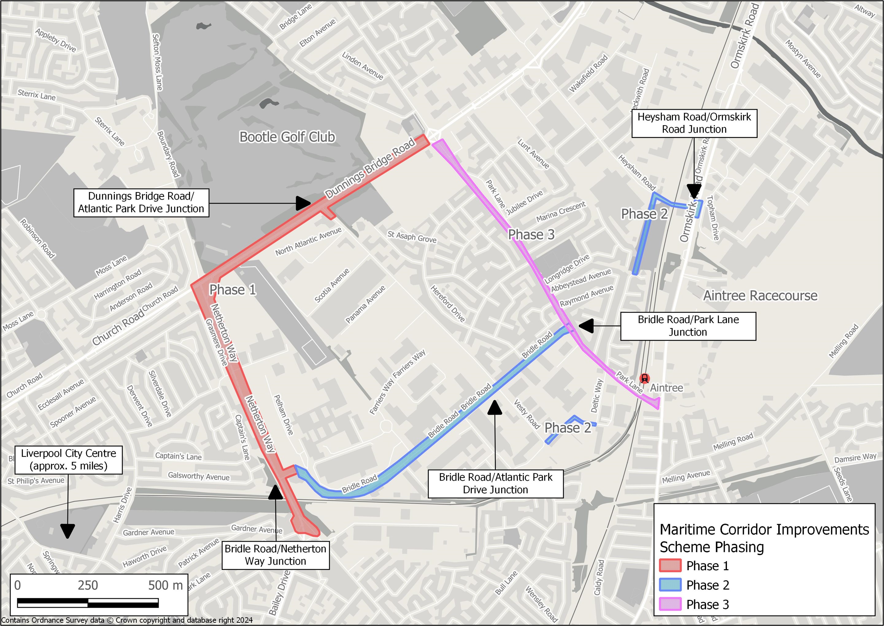
Phase 1 will be implemented by March 2025 and will be funded by the Liverpool City Region Combined Authority’s - Levelling Up Funding.
Phase 2 will be delivered from 2025 onwards and is likely to be funded by the City Region Sustainable Transport Settlements funding.
Funding is currently not committed for Phase 3, however, funding opportunities are being explored to commence with Phase 3 following the completion of Phase 2.
All design related feedback has been passed back to our scheme designers who are finalising the designs, which will then help us secure the funding. The consultation results will be used to inform the next stages of the scheme as the Council moves towards confirming the final designs.
We have picked out the key themes for below. Overall, there was a mixed response to the improvements, with some welcoming the new cycling and walking elements and others more concerned about the effects on traffic and congestion throughout this area. Air quality and the need to maintain and improve green spaces and trees through the wider area was also a key concern throughout.
FINDINGS OF THE CONSULTATION
Within the Your Sefton Your Say survey the public had an opportunity to comment on all individual elements of the scheme. The main findings and answers to some key queries and concerns can be found below:
There were 6 responses from stage 1, however it is noted that further conversations are still taking place between the land agent and landowners in relation to specific elements.
There were 102 online survey responses from stage 2 of the engagement. All have been reviewed and analysed alongside the 9 emails responses that came directly via the Transport Planning inbox, which have been responded to.
We have picked out the key themes and concerns and tried to answer them below:
You said |
We did |
|
CONGESTION CONCERNS Overall congestion Congestion during construction
|
Overall congestion
Congestion during construction |
| AIR POLLUTION There were major concerns about the air quality in the area being bad and possibly getting worse, particularly around the schools in the wider area. There were queries over whether the air quality was currently monitored and plans to improve it. Green walls and other initiatives need to be considered. |
The council monitors air quality throughout the area and the transport team are working with colleagues in our Energy and Environment Teams to look at future monitoring and mitigation that may be needed. In addition, plans to replace and retain trees are being undertaken with Green Sefton who manage the green space across Sefton. We are also looking in detail at the carbon emissions assessment of these works and how we can manage these. |
|
RIMROSE VALLEY The Maritime Corridor is not linked to the potential Rimrose Valley Road scheme and neither are dependent on each other at all in terms of delivery or funding. |
The Maritime Corridor is not linked to the potential Rimrose Valley Road scheme and neither are dependent on each other at all in terms of delivery or funding. |
| REPLACEMENT OF BRIDGE / CROSSING POINT ON DUNNINGS BRIDGE ROAD There was a misconception that the replacement crossing on Dunnings Bridge Road was linked to the Maritime Corridor scheme. There was suggestion of a underpass if a new bridge could not be built. |
The Council’s plans are not related to the former footbridge or its replacement. The replacement of the footbridge in some format is the responsibility of National Highways (previously known as Highways England) and a scheme is currently in development. |
| CYCLE LANES – USAGE AND VALUE There was some key concern that cycle lanes were a waste of money and would not be used. There was questioning about whether the wider cycling improvements would actually be used. |
The scheme has been designed to benefit all users including those in vehicles and those walking and cycling. The aim of the improvements is to make the area more accessible for those who may not have access to a car / vehicle. This is linked to the funding which focuses on offering better access by more sustainable ways of travel. It is highlighted that there were also positive comments about the cycling elements within the responses with people stating that the routes would be used. |
| CONSULTATION WITH CYCLING ORGANISATIONS It was queried if Merseyside Cycling Campaign and Sustrans had been consulted on the plans. |
Merseyside Cycling Campaign, The Trans Pennine Trail and Sustrans were consulted as part of the engagement process. A detailed response has been received from Sustrans on certain elements of the designs and these have been passed onto the scheme designers. |
| DUNNINGS BRIDGE ROAD - Comments were received that the plans would just cause more congestion for motorists and widening the space for motorists should be considered. - Comments were made that cycleway and footways which are already there just need resurfacing. - New crossing was supported but thought not to be in the right places and should give priority to cyclists and walkers. - There were concerns over abrupt stop of cycle lanes on one side (eastern side). |
The Council have modelled the effects of these improvements on traffic flows and the scheme is designed to alleviate congestion. An additional lane is provided at the Dunnings Bridge Road/Atlantic Park junction, providing additional capacity at this location, and there are no areas where carriageway space is being removed. The cycling lanes and footway on Dunnings Bridge Road is limited at present and the improvements are designed to enhance the existing infrastructure, bringing it up to current standards, as well as linking into the wider network. Footways and cycleways within the scheme boundary will be resurfaced as part of the scheme. Comments in relation to the position of crossing points and the need to link up to existing cycling networks have been passed on to the designers. The scope and budget for these improvements is limited however the Council are exploring further how to provide an integrated cycling network across the wider Borough. |
| PARK LANE - Concerns that would impact dropped kerbs at properties 148- 154. - Concerns would restrict areas for visitors and residents to park. - Suggestion to change speed limit to 30mph instead of 20mph. - Traffic may turn over the cycle path. - More bins needed on Park Lane and Park Lane West. - Needs to link to other networks for cyclists better. - Suggestion of parking layby by the takeaway / shops. - Suggestion of changing traffic light timings and having a crossing near to our Lady of Walsingham Church. - Bus stops should be lay by so traffic can flow easier |
This element of the project will be delivered in Phase 3. The Council are continuing discussions with key stakeholders around the improvements and the designs are currently under review for this part of the scheme. This review will consider all design related comments. |
| VESTY ROAD TO DELTIC WAY - Concerns that this route would not be used by cyclists. - Concerns that this route would still be busy with HGVs. - Suggestion that more trees needed along this section. - Needs to be better linked up to existing cycling networks. |
The Council are continuing discussions with key stakeholders around the improvements and the designs are currently under review for this part of the scheme. This will consider all the feedback. |
| NETHERTON WAY - Concerns were raised over the removal of the bus lay by on Netherton Way near to the school which may cause collisions and more congestion. - The designs were a little hard to understand and look a bit busy and confusing. - Congestion and backlash from drivers could be expected. |
The Council are continuing discussions with key stakeholders around the improvements and the designs are currently under review for this part of the scheme. This will consider all the feedback. Following a detailed review of the bus lay-by on Netherton Way, including stakeholder engagement, a decision has been made to retain the existing bus lay-by. The Council are also aware that The Salesian Academy of St John Bosco have plans to rebuild on the school site and are in discussions with the school. |
| BRIDLE ROAD - Noted that raised tables are needed at all side roads. Current designs do not provide a continuous cycling route. - Pinch points will not be alleviated and this will cause more problems for HGVs. |
Design related comments in relation to side road crossing and pinch points have been passed onto the designers. This element of the scheme is also being discussed with Active Travel England. |
| HEYSHAM ROAD - Sustrans were in favour of this element of the scheme however made some suggestions around creating proper barriers for cyclists, which have been passed onto the scheme designer. - HGVs will cause dangers if turning. - Will cause traffic to build up on Dunnings Bridge Road, Ormskirk Road, Park Lane and Copy Lane. - Signalise the underpass and let cyclists and walker go at separate stage to traffic. - Needs lights at Galgate Drive. - Flooding and drainage issues need to be sorted first. - Does not link up to existing cycling network. |
Comments in relation to the position of crossing points and the need to link up to existing cycling networks have been passed on to the designers. The scope and budget for these improvements is limited however the Council are exploring further how to provide an integrated cycling network across the wider Borough. The designs for this element of the scheme are being reviewed based on recent traffic surveys and modelling. |